This is a ‘mash-up’ metro style map (2025 edition) which highlights the majority of museums and attractions in Amsterdam.
With a sprinkle of inspiration from some of the world’s iconic metro maps, this unique map gives you a visual perspective of the city’s museums loosely based on their geographical location.

With a total of 91 points, the map illustrates Amsterdam’s rich and diverse collection of museums and attractions.
Amsterdam has one of the highest number of museums per capita in the world.
Please note that these are not real metro lines and the map is not exactly to scale! Go here for the real Amsterdam Metro Map
Our 4 virtual lines are as follows:
- The blue Central line ■ runs north-south from NXT Museum in Amsterdam Noord to the RAI Amsterdam exhibition centre in the south.
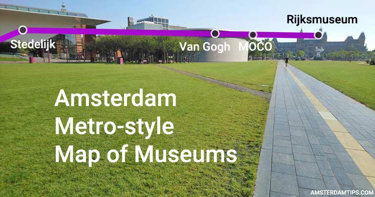
- The purple Olympic Line ■ runs via the main museum district on Museumplein and past the Olympic Stadium towards Schiphol airport (which has its own small Rijksmuseum exhibition).
- The green Canal line ■ follows the inner horseshoe ring of the city’s 17th century canal belt. It runs from STRAAT Museum at NDSM wharf in the north-west to Museum Noord in the north-east.
- The yellow Rembrandt line ■ named of course after Dutch artist Rembrandt van Rijn, runs from the Embassy of the Free Mind through Amsterdam Central and heads in a south-east direction via the Rembrandt House and along Plantage before terminating at the Vrolik Museum in Amsterdam Zuid-Oost.
We decided the appropriate ‘interchange station’ for the Canal, Central and Olympic lines should be Stadsarchief, the city archives.
If you are curious about any of the stops we have included a brief description of each here:
| Stop | Line(s) | Description |
| STRAAT Museum | ■ | Amazing street art in a 8,000m² former shipping warehouse |
| AMAZE Amsterdam | ■ | Immersive audio-visual experience in an old industrial nightclub |
| van Eesteren Museum | ■ | Small museum pavilion overlooking Sloterplas lake |
| Het Schip | ■ | Monumental apartments showcasing Amsterdam School of architecture |
| Fabrique des Lumières | ■ | Immersive art exhibitions using cutting-edge projection and music |
| Noorderkerk | ■ | Northern church used for exhibitions and concerts |
| Electric Ladyland | ■ | Quirky small museum of fluorescent art |
| Tulip Museum | ■ | Small but in-depth exhibition about tulips |
| Anne Frank House | ■ | House with secret annex where Anne Frank hid in WW2 |
| Westerkerk | ■ | Western church and tower that also hosts concerts |
| Houseboat Museum | ■ | A traditional Dutch houseboat open for visitors |
| Felix Meritis | ■ | Monumental building and cultural meeting house |
| Museum of the Canals | ■ | Highlights the history of Amsterdam’s canals in a grand house |
| Huis Marseile | ■ | Contemporary photography museum on the Keizersgracht canal |
| Pipe Museum | ■ | Museum on the culture of pipe smoking |
| Cat Cabinet | ■ | Museum with a unique art collection based around cats |
| Stadsarchief | ■ ■ ■ | The Amsterdam city archive and historical documentation centre |
| Van Loon Museum | ■ | Double canal house and garden open to the public |
| Willet-Holthuysen House | ■ | Grand canal house from the 17th century |
| H’ART Museum | ■ | Former Hermitage, hosts major exhibitions on art and history |
| Outsider Art | ■ | Museum of the Mind’s Outsider art collection |
| Rembrandt House Museum | ■ ■ | The house where artist Rembrandt van Rijn lived and worked |
| ARCAM | ■ | Architecture Centre Amsterdam hosts exhibitions on urban development |
| OBA Library | ■ | Amsterdam’s central library on Oosterdok |
| NEMO | ■ | Science and technology museum for youngsters in an iconic green building |
| Maritime Museum | ■ | Het Scheepvaartmuseum showcases Dutch maritime history |
| Oosterkerk | ■ | Eastern church that hosts regular concerts and exhibitions |
| WONDR | ■ | Fun and immersive pop-up experience in Amsterdam |
| Museum Noord | ■ | Small museum about the development of north Amsterdam |
| NXT museum | ■ | ‘New media art’ museum with immersive exhibitions |
| This Is HOLLAND | ■ | 5D flight experience over Dutch landscapes |
| EYE Film Museum | ■ | Modern white building with film museum and cinema |
| A’DAM Lookout | ■ | Panoramic viewpoint at the A’DAM Toren building |
| Amsterdam Centraal | ■ ■ | Amsterdam’s Central Station, a major transport hub |
| Sexmuseum | ■ | Popular museum exploring sexual themes |
| Body Worlds | ■ | Exhibition of ‘plastinated’ human bodies |
| W139 | ■ | Presentation and production space for contemporary art |
| Nieuwe Kerk | ■ | New Church on Dam Square hosts regular exhibitions |
| Royal Palace | ■ | The imposing Royal Palace on Dam Square |
| Madame Tussauds | ■ | Popular celebrity wax work museum on Dam Square |
| Ripley’s | ■ | Ripley’s Believe It or Not exhibition on rarities and oddities |
| Amsterdam Museum | ■ | Museum on Amsterdam’s history, currently under renovation until 2028 |
| Amsterdam Dungeon | ■ | Interactive group show through dungeons with live actors |
| Allard Pierson | ■ | Archaeological museum with ancient artifacts |
| Torture Museum | ■ | Museum with torture implements from the middle ages |
| FOAM | ■ | Renowned Amsterdam photography museum |
| BonTon | ■ | Tour of a strip-club with a former sex-worker |
| Heineken Experience | ■ | Tour the former Heineken Brewery |
| De Dageraad | ■ | Take a tour of this Amsterdam School housing complex |
| The Upside Down | ■ | Instagram experience which has 25 mind-bending rooms |
| RAI Amsterdam | ■ | Main exhibition and convention centre in the city |
| Schiphol Airport | ■ | Amsterdam’s international airport |
| Museum JAN | ■ | Visual arts museum with a focus on glass |
| CoBrA Museum | ■ | Museum on the Cobra avant-garde art movement |
| Olympic Stadium | ■ | Historic stadium used for the 1928 Olympics |
| Tramway | ■ | Take a ride on the museum tramline in Amsterdam |
| Living Horse Museum | ■ | Museum in the oldest riding school of the Netherlands |
| Stedelijk | ■ | Museum for contemporary and modern art and design |
| Van Gogh Museum | ■ | The largest collection of Vincent Van Gogh works |
| House of Bols | ■ | Cocktail and genever experience about the Lucas Bols brand |
| MOCO Museum | ■ | Modern-contemporary art including Banksy |
| Diamond Museum | ■ | Diamond-themed museum by Royal Coster Diamonds |
| Rijksmuseum | ■ | Amsterdam’s principal museum with a magnificent art collection |
| Max Euwe Centre | ■ | Chess themed museum named after a Dutch grandmaster |
| Rembrandts Amsterdam | ■ | Immersive audio-visual presentation on Rembrandt’s later years |
| Embassy of the Free Mind | ■ | Museum and library promoting freedom of thought |
| Multatuli Museum | ■ | Museum on the Dutch author who wrote the novel Max Havelaar |
| Cat Boat | ■ | A floating sanctuary for stray and abandoned cats |
| Op Solder Museum | ■ | House with a hidden Catholic church in its attic |
| Ouderkerk | ■ | The old church, Amsterdam’s oldest building |
| Erotic Museum | ■ | Erotic-themed museum |
| Red Light Secrets | ■ | Museum of prostitution set in a former brothel |
| Hash Museum | ■ | A museum dedicated to the cannabis plant |
| Zuiderkerk | ■ | Southern church and its tower |
| Jewish Museum | ■ | Museum on the Jewish faith and its rituals |
| Portuguese Synagogue | ■ | Historic 17th century synagogue |
| Hortus Botanicus | ■ | Old botanical gardens with 4,000 plant species |
| Luther Museum | ■ | Museum on Dutch Lutheran heritage with period rooms |
| Holocaust Museum | ■ | Museum on the holocaust from a Netherlands perspective |
| Hollandsche Schouwburg | ■ | Dutch National Holocaust Memorial in a former theatre |
| Verzets Museum | ■ | Museum about the Dutch resistance in WW2 |
| Micropia | ■ | World’s first museum about microbes and micro-organisms |
| ARTIS | ■ | Picturesque zoo in the heart of the city |
| Groote Museum | ■ | Museum about the connection between all forms of life |
| Suriname Museum | ■ | Museum about Suriname, open in 2025 |
| Wereldmuseum Amsterdam | ■ | Ethnographic museum about non-Western cultures |
| Framer Framed | ■ | Platform for contemporary art, visual culture, critical theory & practice |
| Tot Zover | ■ | Museum about death and funeral rituals |
| OSCAM | ■ | Open Space Contemporary Art Museum in the multi-cultural Bijlmer district |
| Johan Cruijff ArenA | ■ | Football stadium home of AFC Ajax named after the Dutch legend |
| Vrolik Museum | ■ | Museum with anatomical and embryological specimens |
Anyway, we hope you find it a fun and useful visual overview on your journey around Amsterdam’s museums!
This is the 5th edition of the Amsterdam Museums metro-style map, published on 23 January 2025. This minor update has removed Our House and NEMO Studio (both closed down) and added the Suriname Museum.
Concept and design by AmsterdamTips.com. Previous editions were published 9 Sep 2014 (1st), 6 Nov 2025 (2nd), 11 Nov 2019 (3rd) and 11 Jun 2024 (4th).


